Paranoia
I realise that most of you who look at this blog do so to watch the progress on my steam engines, and lately you have been getting a lot of weird stuff about Antarctica.
Well, this is another one about Antarctica.
Suddenly, the Google Earth images of the area of Antarctica which I have found very interesting, have been blotted out with a crude graphic which blots out the items of interest.
The crude graphic looks a bit like cloud cover from a distance, but it does not change over the years timeline and close up it is obviously not real cloud.. Look at the screenshots below, and notice the relation of the graphic to my placemarks, which were inserted by me before the blotting out graphic appeared.
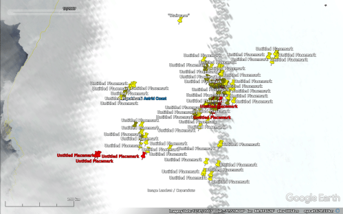
The blotting out graphic is the two “checkerplate” strips and the area between and nearby. See how it neatly includes my placemarks.


The “Atmosphere” setting in Google Earth is off. But it persists in some areas. And look how it neatly includes all of my placemarks.
Come on guys! This is beyond coincidence. Someone does not appreciate my posts about the odd shapes in this region.
Either that, or I am really going a bit pararoid.