
Antarctic Sphinx
When scanning Antarctica with Google Earth Pro today, which I do from time to time, I came across this flattish circular shape on top of a mountain…

Zooming in….

The Disk pin locates a tiny dot of interest…. 6 Nov 2012. Moving the Timeline date does not change the image.
It is 10km diameter, and fairly flat and smooth. The above photo was taken from 10.5km altitude.
You will note my marker labelled “Disk”. It marks a black dot, which I zoomed into….
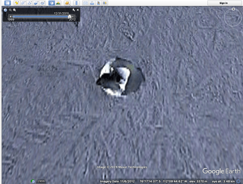
Well, that looked a bit odd… quite circular, intense white and black areas. 31 meters diameter. The co-ordinates are on the screen if you want to check this yourself. Note the shadow to the west. It indicates that the central round lump with the “face” is actually a substantial pillar, with straight sides. There is nothing anything like it that I have seen, anywhere else in Antarctica.
So what is it? Zooming in closer (in 2012) does not improve the clarity. ?an odd heat vent causing local melting?
A bit of further checking reveals that the area is an 11352′ (3460m) volcano, which protrudes 2100m above the surrounding ice sheet. Mount Takahe. 76.28S, 112.08W, in West Antarctica. It is a large “shield volcano” which last erupted in 5550BCE. It erupted massively 17,700 years ago, and is thought to have accelerated the end of the last ice age. The smooth flat area in photos 1 and 2 is the caldera of the volcano.
That is very interesting, but does not answer the question… what is the strange “sphinx” like protrusion in the 3rd photo.
The above images were made in 2012. I cannot find any other zoomable satellite images of this area, despite other areas of Antarctica being photographed at least annually, and in some areas, several times per year.
Also, satellite images of most of the world’s volcanoes are available at http://www.volcanodiscovery.com , but Mt Takahe’s images are blacked out!
Please excuse my paranoia. And the clickbait heading.

The flat top is the ice filled caldera.

Almost worth travelling to inland Antarctica, and climbing an 11,000′ volcano to find out. Almost.
Oh, and by the way, there is a pyramid, or a mountain which looks distinctly pyramidal, in Antarctica… Look it up.
PS. 2 days later. Doing some more checking on Mt Tahake, I came across this YouTube video. I was not the first to think that there is some strange stuff there.
