
More Antarctic Weird – 2
by John
Harking back to the Google Earth photos which I posted on Jan 6 2018. “More Weird Stuff”. The photo was from 1999 satellite imagery. Why am I so obsessed with this? I am not sure. Please read on.
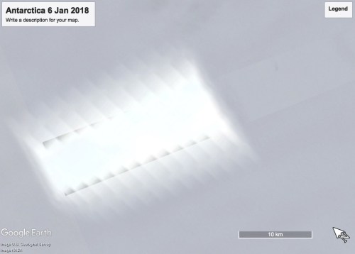
This 21x7km black rectangular shape/object in Antarctica. With the white reflections? white-out?. And the track(?) leading from the south -east. I occasionally re-open Google Earth Pro to look at it, and wonder what it was. I have scanned all over Antarctica, and have never seen anything else, remotely like this.
Google Earth Pro has a feature which allows the viewer to scan back and forth over the years to see how a site changes. Guess what. The above shape does not show up on the yearly images even 1999.
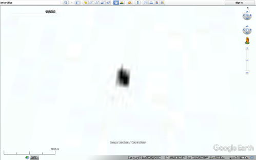
Then in the 2006 imagery I noticed a tiny black dot on my screen, near to where the big black rectangle was previously. The tiny black dot would not brush off my screen, so I zoomed in. This is what appeared.

That black dot is sited in a white rectangle which measures 300m x 150m. A pixellated natural feature I thought. But scanning other areas of Antarctica does not show any pixellation anything like this.
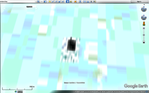
Then I searched the vicinity. And found dozens and dozens of similar objects. Nearly all 300m long, and either 150 or 200m wide. All with a central black area. All with smaller grey shapes in the white areas. Scattered around an area of 300 x 300 kilometers (~200 x 200 miles). Some areas clearer than others, probably due to atmospheric conditions. I started to count them, but stopped at 100. Most of them were oriented close to North-South.
They only appear in the years 2004 to 2007, and they are stationary. 2006 is the clearest.
Then recently, I purchased a photo editor, and played around with settings on some of the screen shots which I had taken of the “objects”.
Unedited Google Earth photo. The coordinates are there if you want to check for yourself. The white rectangle surrounding the black area is different from the surrounding snow-ice.

Defogging turned up, with compensation
Defogging turned up, without compensation.
These do NOT look like pixellated natural features.
There are too many, and too big to be man-made.
And they are scattered around the area of the 1999 image of the 26km x 7km black rectangle.
DOES ANYONE HAVE ANY IDEA WHAT THEY ARE?
p.s. The parallel lines which I puzzled about previously are probably artifacts arising from the Landsat photography. Thanks to reader Brendan for the technical article which lists various anomalies in pictures which are stitched together from multiple passes of the satellite. Still no explanation for the 300m x 150m rectangles shown in this post.

Baffling objects and clouds…
LikeLike